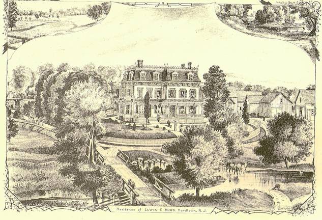
With the commotion about sinkholes on Route 80, it might be time to look closer into one of the mines in that area. This is the Hurd Mine, now abandoned.
Recently, I explained some of the reasons for the Route 80 sinkholes along with a little history.
The Hurd Mine is interesting because with it, we can talk more about Sussex County history and mining operations here.
The Hurd Mine was one of the largest, deepest and most productive iron mines in New Jersey in the late 1800s.
During that time, New Jersey was one of the most significant mining regions in America. The veins that contained iron generally would start at the surface and extend at an angle to perhaps 600 feet in depth.
The veins were usually a straight line. Looking down from above the Earth, these many veins went on a generally northeast to southwest direction, following the lay of the Appalachian Mountains.
The ore was magnetite, which is a black rock. When I show schoolchildren a specimen of this rock, I throw a magnet at it and it sticks, illustrating the nature of the mineral.
The Hurd Mine was in Hurdtown (what a coincidence!), which is in Jefferson near Lake Hopatcong. The center of the town was near what was known for many years as the Pathmark Shopping Center, where the Jefferson Diner is today.
The actual mining was in the cloverleaf just north of the mall. The spot had to be refilled several times over the years because of settling.
The owner, Lewis Hurd, had a nice house on the site. There have been several restaurants on the location.
When I was a boy, there was the Three Sisters, which burned, then Gatwins for many years.
There was another Hurd homestead in the middle Sparta, torn down for the A&P Shopping Center in the 1960s. Now it is the Post Office mall.
The location has a lot of interesting pieces to it. Just to the west of the home ran a turnpike, known on the 1868 map as the Dover-Sparta Turnpike. This was a main route for the stagecoach.
In the same period, the Ogden Railroad, later known as the Edison, ran from the iron mines atop Sparta Mountain above Ogdensburg to the canal boats on Lake Hopatcong and also served the huge icehouse on Nolans Point.
Lake Swananoa served as the water supply and may have been used for power to run a furnace or forge or milling operation.
Close by was Lake Hopatcong, which would have been convenient to cart the ore before the railroad.
This pen sketch (probably a wood cut) from the mid- to late 1800s is a view showing a beautiful home with a mansard roof and ornate trim; two wooden bridges; the locomotive steaming over the turnpike, where a two-horse-drawn buckboard can be seen; horses drinking from the stream from Swananoa; and several buildings in the back for the industry. These buildings match the ones on the postcard that accompanied this column last week.
All this is lost to society and our common knowledge.
Enjoy and appreciate our past.
Bill Truran, Sussex County’s historian, may be contacted at billt1425@gmail.com